Sustainable Transportation Accommodates All Roadway Users
Over the past five years, there has been a significant shift in the way that many communities approach planning for improvements to their transportation infrastructure. Sustainable transportation is a movement that’s been sweeping the country as more attempts are made to develop a healthy transportation that is compact and accommodates all roadway users. More and more initiatives are encouraging transportation planners to rethink the traditional manner in which a town or city’s streets are designed, as well as their functionality.
These initiatives often are inspired by the concept of Complete Streets (www.completestreets.org), which promotes the design and construction of safe and efficient transportation networks at the local level—for all users, regardless of ability, and whether they choose to bike, walk, ride mass transit, or drive. It is a plan to accommodate all roadway users that benefits everyone.
An example of a Complete Street is seen in Figure 1, which shows provisions for bicycles (a bike lane in this case), pedestrians and vehicles, all within the same right-of-way.
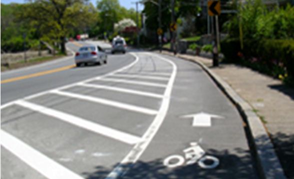
As shown here, the Complete Streets concept puts an emphasis on mode choice alternatives to the conventional automobile, a concept that is regarded as environmentally friendly. In fact, a fully realized Complete Streets plan can also have positive environmental effects, including improved outdoor air quality through the reduction of traffic congestion and enhanced stormwater runoff management, as well as health benefits for the pedestrians and bikers.
Alternate modes of transportation
There is no single design template for Complete Streets; each concept and plan is as unique as the community in which it is implemented. Many times, a Complete Streets project is retrofitted into the specific context type, whether it’s rural, suburban or urban. However, most plans involve the creation or enhancement of pedestrian and bicycle-related features—features aimed at getting users to leave their cars behind in favor of alternate modes of transportation.
For example, multi-modal intersections link pedestrian services with those for bicycling and mass transit, which are inter-related. Once a transit user leaves the transit vehicle, he/she typically becomes a pedestrian. Improved directional and information signage and pavement markings alerting pedestrians to the location of crosswalks, street furniture (benches, way-faring signs), bike racks, drinking fountains, street merchant pads, and other amenities is very important.
An example of a before-and-after condition of a Complete Street project is shown in Figures 2 and 3.
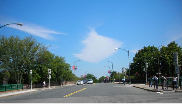
Figure 2 shows the existing condition of the Anderson Memorial Bridge in the Boston/Cambridge, Mass., area, where there is expansive pavement width, four lanes of traffic, and little or no provisions for pedestrians or bicyclists.
 Figure 3 shows the project as currently under design (it’s slated for construction in 2012).
Benefits include reduction in the number and width of vehicle travel lanes, as well as better definition of these lanes, the addition of bike lanes, improved accommodations for pedestrians by increasing the sidewalk length, connectivity for bicycles and pedestrians, and reduced and safer crossing distances for pedestrians.
Other improvements within the project limits include reducing the length of cross walks, adding median islands, making pedestrian signals more accessible and more pedestrian friendly, and extending curbs.
Of course, encouraging individuals to walk also involves measures aimed at ensuring their safety. One way municipalities are accomplishing this is by reducing the pavement width of arterial streets. Wider streets encourage motor vehicle operators to drive faster. By narrowing the pavement for the travel way, the speed of the traffic is slowed, making the street safer for pedestrians.
More road space for bicyclists
Towns and cities are also designating roadway space for bicyclists. Clearly, bicycling has become a bigger part of our culture, both for recreational and commuting use. As a result, one of the most popular facilities is the bicycle lane, which is delineated from the adjacent motor vehicle travel lane by striping or pavement markings.
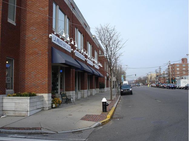
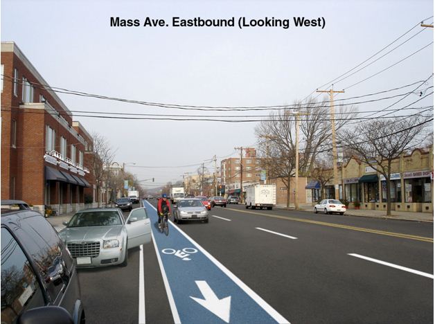
Figure 4 below shows “before” conditions and Figure 5 shows “after” conditions along Massachusetts Avenue in Arlington, Mass. In the 1950’s there were trolley tracks in the middle of this 66-foot wide roadway, as well as travel lanes and parking along both sides of the roadway. Since then, the trolley tracks have been removed, but no provisions have been included for other roadway users. Figure 5 shows a dedicated bike lane (thus re-claiming some of the pavement), a reduction in travel lanes particularly since the vehicle demands have reduced over time, improvements for pedestrian crossings, and maintenance for parking.
Bicycle lanes typically measure four to six feet in width and are located on the right edge of the roadway (though they can be designated to the left of parking spaces or right-turn lanes).
Bicyclists also are accommodated by the wide curb lane (WCL), which measures 13 to 15 or more feet in width. The extra space allows the lane to be shared by motor vehicles and bicycles while giving sufficient room for automobiles to pass.
Bicycle lanes and WCLs are each beneficial in their own way. Advocates of WCLs believe that wider lanes encourage bicycle riders to operate more like motor vehicles, which leads to more correct maneuvering at intersections.
Meanwhile, studies have shown that a bicycle lane’s stripes or pavement markings result in fewer erratic driver maneuvers, more predictable bicyclist riding behavior, and enhanced comfort levels for both. In the past, when bicycles riding adjacent to parked vehicles were involved in accidents, these types of incidents were typically referred to as “dooring.” With a dedicated bike lane, however, the cyclist is typically riding in the middle of the lane and “dooring” is less likely to occur. However, some bicycle lane opponents feel these facilities make it difficult for bicyclists to handle turning maneuvers at intersections, particularly right turns.
Each facility is proving effective in encouraging residents and visitors to consider bicycling, which lessens the amount of motor vehicles on a roadway and improves air quality.
Better stormwater runoff management
Complete Streets policies also can be used to develop more efficient stormwater runoff systems. While designing new sidewalks, communities can consider and implement porous pavement that allows stormwater runoff to filter through to the ground beneath. In addition, rain gardens planted along sidewalks can help facilitate runoff while specially chosen plantings lower nitrogen and phosphorus levels in the receiving water. Other design elements include engineered composite soils, which store and treat runoff, and specially structured soils for tree plantings that feature grates and drains that irrigate the plantings.
By decreasing roadway widths, the opportunities for installing grass strips and plantings also decrease pervious surfaces. Municipalities also are planting trees and shrubs to enhance the environment and improve air quality. Leaves filter the air by removing dust and other particulates and absorb carbon dioxide. Trees and shrubs reduce thermal pollution and urban heat island effects. Thermal pollution is the harmful increase of water temperatures in rivers, streams, and lakes. Stormwater runoff can get hotter as it washes across impervious surfaces. When the heated runoff enters a natural water source, it can negatively affect fish and other wildlife that need cold water to live and breed.
Innovative technologies
Planners and engineers are using innovative technologies to make roadways safer and environmentally friendly for all users. These technologies include:
-
LED street lights, which offer longer life spans, lower energy demands, and reduced maintenance costs;
-
On-street cameras and sensors, which analyze real-time traffic and parking trends, and can ensure smoother traffic flow and reduced traffic congestion;
-
Barcodes and radio-frequency identification tags, which provide smart phone users with access to information regarding nearby bike-sharing programs, scooter parking, and electronic vehicle charging stations;
-
Countdown pedestrian signals;
-
Leading pedestrian intervals (LPI’s) at traffic signals, which give the pedestrian the advance prior to the vehicle receiving the green indication;
-
Better timed traffic signals and improved or additional crossing times for pedestrians;
-
And GPS devices, which help provide more efficient travel.
An interesting example of this is provided in the City of Salem, Mass. With the support of the Mayor and other local officials and interests, the city developed a citywide bicycle circulation master plan. The plan identified the extent of shared roadways that should be designated as bicycle routes by using “sharrows” (a shared-lane marking on a street), as well as those roads that are suitable for bike lanes and corridors for exclusive bike paths.
Further, the plan called for the creation of more than 33 miles of designated bicycle routes within the city, including over four miles of bikeways, more than six miles of bike lanes, and another 22-plus miles of shared bike routes. The study also included a detailed evaluation of a high priority 4.5-mile “pilot” route, as well as construction cost estimates and maintenance costs. Currently, the city is in the process of developing the pilot route.
As you can see, throughout the Northeast and the country, programs based on Complete Streets initiatives are making roads more accessible for drivers, cyclists, and walkers. Planning and designing roadways that are friendly toward all users enhances a municipality’s efforts to promote environmentally friendly solutions. The end result is a richer quality of life.
Dean L. Groves, P.E., is president and chief executive officer of Fay, Spofford & Thorndike Inc. During his 38-year career, Groves has focused on transportation planning and environmental documentation in connection with complex transportation projects, and municipal engineering. Doug Prentiss, P.E., P. T.O.E, principal traffic engineer, is currently involved in a statewide Complete Streets initiative in Massachusetts.