End-of-Summer Arctic Sea Ice Extent Eighth-Lowest on Record
And Antarctica is heading to its maximum yearly sea ice extent, which typically occurs in September or early October. NASA reported this year's maximum extent is likely to be among the five lowest in the satellite record — a continuation of the low extents in 2015 and 2016.
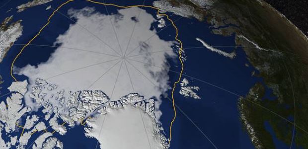
Arctic sea ice appeared to have reached its yearly lowest extent on Sept. 13, researchers at NASA and the NASA-supported National Snow and Ice Data Center (NSIDC) at the University of Colorado Boulder have reported. Their analysis of satellite data showed that at 1.79 million square miles (4.64 million square kilometers), this year's Arctic sea ice minimum extent is the eighth lowest on record; the satellite record began in 1978.
The image at the top of this article shows Arctic sea ice on Sept. 13, 2017, when the ice reached its annual minimum. The yellow line marks the 30-year average minimum sea ice extent from 1981 through 2010. (Credit: NASA's Scientific Visualization Studio/Helen-Nicole Kostis)
The minimum summer extent of the Arctic sea ice typically occurs in September. The extent has been decreasing, overall, rapidly since the late 1970s due to warming temperatures.
NASA reported that this year, temperatures in the Arctic have been relatively moderate for such high latitudes and even cooler than average in some regions. But the 2017 minimum sea ice extent is 610,000 square miles below the 1981-2010 average minimum extent.
"How much ice is left at the end of summer in any given year depends on both the state of the ice cover earlier in the year and the weather conditions affecting the ice," said Claire Parkinson, senior climate scientist at NASA's Goddard Space Flight Center in Greenbelt, Md. "The weather conditions have not been particularly noteworthy this summer. The fact that we still ended up with low sea ice extents is because the baseline ice conditions today are worse than the baseline 38 years ago."
According to NASA, the three years with the lowest Arctic ice extents on record were 2012, 2016, and 2007, and all experienced unusual weather conditions, including strong summer storms that accelerated melting of the ice cover. "In all of those cases, the weather conditions contributed to the reduced ice coverage. But if the exact same weather system had occurred three decades ago, it is very unlikely that it would have caused as much damage to the sea ice cover, because back then the ice was thicker and it more completely covered the region, hence making it more able to withstand storms," Parkinson said.
Antarctica is heading to its maximum yearly sea ice extent, which typically occurs in September or early October, and NASA reported this year's maximum extent is likely to be among the five lowest in the satellite record — a continuation of the low extents in 2015 and 2016 that represented a dramatic turn of events after a streak of record high maximum extents in 2012, 2013, and 2014. "What had been most surprising about the changing sea ice coverage in the past three decades was the fact that the Antarctic sea ice was increasing instead of decreasing," said Parkinson. "The fact of Arctic sea ice decreases was not as shocking because this was expected with a warming climate, although the overall rate of the decreases was greater than most models had forecast." She said that although it is still too early to talk about a long-term reversal in the behavior of Antarctic sea ice, the decreases of the past two years provide important data to test the various hypotheses that scientists have put forward to explain why Antarctic sea ice coverage had been increasing overall between 1979 and 2015.