The Cascadia Fault: Overlooked and Underprepared
- By Julia Troute
- Jul 16, 2015
In late 2004, an undersea megathrust earthquake occurred off
the west coast of Indonesia when the Indian Plate was subducted by the Burma
Plate, triggering a series of devastating tsunamis along most landmasses bordering
the Indian Ocean. The earthquake and subsequent tsunamis killed over 230,000 people
in 14 countries, plowing through coastal communities with waves up to 100 feet
high. With a magnitude of 9.1–9.3, it was the third-largest
earthquake ever recorded.
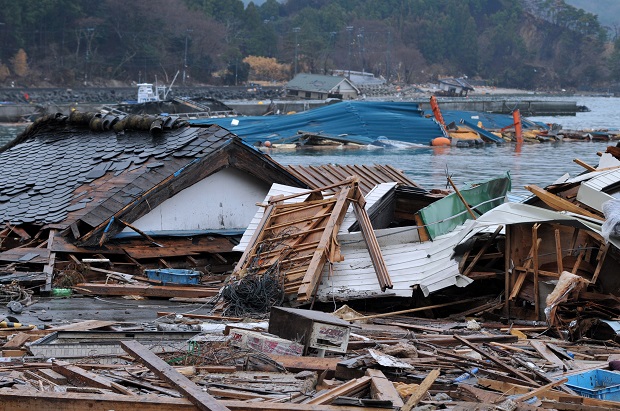
In 2011, another undersea megathrust earthquake occurred off
the coast of Japan, producing powerful tsunami waves that reached over 130
feet. With a magnitude of 9.0, the earthquake and tsunami that followed caused
15,891 confirmed deaths, 6,152 injuries, and left 2,584 people missing. It was
the most powerful earthquake to ever hit Japan and the fourth-largest earthquake ever recorded.
When North Americans talk about “The Big One,” they’re often
referring to the earthquake and subsequent destruction that is assumed to eventually
take place along the San Andreas Fault. But, just north of the California’s
most famous fault line is the lesser known and far more insidious Cascadia
subduction zone running 750 miles from Vancouver to Northern California. As
Kathryn Schulz reported for The New
Yorker earlier this week, this somewhat mysterious fault is nearly three
quarters of a century overdue for a massive earthquake, estimated to be
anywhere between 8.0 and 9.2 in magnitude.
In 2013, The Seattle Times science reporter Sandi
Doughton released Full-Rip
9.0, a book highlighting the “scientists who are dedicated to
understanding the way the earth moves,” what patterns can be identified, and
how prepared people are—or, in the case of Seattle, Portland and Vancouver, how
vulnerable our Pacific Northwest actually is. Almost three hundred people died
in Hurricane Sandy. Nearly 2,000 were killed in Hurricane Katrina. Over 3,000 lost
their lives in San Francisco’s great earthquake of 1906. As Schulz reported in The New Yorker, "FEMA projects that
nearly thirteen thousand people will die in the Cascadia earthquake and
tsunami. Another twenty-seven thousand will be injured, and the agency expects
that it will need to provide shelter for a million displaced people, and food
and water for another two and a half million.”
The most alarming question to come from all of this data is
not “if” but “when” as geologists can now guarantee that this catastrophe of
colossal proportions is on its way. By the time the aftershocks have stopped
and the water has receded, “the region will be unrecognizable.” Kenneth Murphy,
who directs FEMA ’s
Region X, the division responsible for Oregon, Washington, Idaho, and Alaska,
says, “Our operating assumption is that everything west of Interstate 5 will be
toast.” In the Pacific Northwest, everything west of Interstate 5 includes
Seattle, Tacoma, Portland, Eugene, Salem, Olympia, and over seven million
people. When the Cascadia earthquake and tsunami occurs, that region will have suffered
the worst natural disaster in the history of North America. Survivors will be
few, and the landscape of the United States will be changed forever.
About the Author
Julia Troute is a freelance associate content editor.