Navigating a Smart User Strategy
Improved packages make work easier at water industry jobs
- By Uzair Shamsi, Ph.D., P.E., GISP
- Oct 01, 2007
 Geographic information
system (GIS)
software represents
less than 10 percent
of the total GIS
implementation cost
in most cases, yet many people spend a lot of
time selecting the best software for their GIS
applications. This is actually a good thing,
because the success of any GIS program largely
depends on its users—who are not happy if
they do not like their GIS software.
Geographic information
system (GIS)
software represents
less than 10 percent
of the total GIS
implementation cost
in most cases, yet many people spend a lot of
time selecting the best software for their GIS
applications. This is actually a good thing,
because the success of any GIS program largely
depends on its users—who are not happy if
they do not like their GIS software.
Though the art of GIS has been in existence
since the 1970s, the science was restricted
to skilled professionals. In the 1980s, only
a few dozen GIS-related software vendors had
emerged. Thanks to the explosive growth and
popularity of GIS in the 1990s, this number
grew to more than 500 vendors. After numerous
consolidations, mergers, and failures, there
are approximately 150 GIS-related software
companies today. The software sector accounts
for over half of the total worldwide GIS revenues
of over $3 billion.
GIS technology is changing rapidly. New
GIS applications are evolving, mainly due to
the successful marriage of GIS and the Internet.
The GIS applications are being fueled by
recent advances in wireless, Internet, networking,
and satellite technologies. The cost
of spatial data is falling rapidly due to competition
in data acquisition, processing, and
distribution. More intuitive and simpler interfaces
are taking GIS beyond the world of the
GIS geeks. User interfaces are becoming
friendlier, wizards are replacing obscure command
lines, and use of GIS by semi-skilled
end users is growing. These factors are resulting
in evolution of new GIS applications at
an unprecedented rate (Shamsi, 2005). Major
innovations in GIS software for water utilities
are as follows.
User-friendliness
Until the mid-1990s, GIS software was very
difficult to use. There was no graphical user
interface containing menus, buttons, or tool
bars. Users had to type a “command” in a specified
format (syntax) to process GIS data. If
the user forgot this format and mistyped the
command or even missed a comma in the
command, the function wouldn’t run but
would issue an error message. For example, the
earlier versions of one of the most popular GIS
software programs, ArcInfo from Environmental
Systems Research Institute (ESRI), had
nearly 2,000 commands and required 10 days
of training to master these commands. The
mid-1990s witnessed the inception of a new
generation of user-friendly desktop GIS packages
that significantly contributed to an explosive
growth of GIS applications throughout
the water utility industry. Today’s GIS software
is so user-friendly that even first-time users can
be put to work after one to two days of training.
The intuitive Windows-like graphical user
interface loaded with menus, buttons, tool bars,
screen tips, and searchable online help systems
have made GIS software as easy to use as a
spreadsheet.
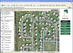
Internet GIS
The Internet allows us to use GIS without ever
buying the GIS software or installing it on a
computer. If you have a computer with an
Internet connection, you can access the basic
functions of GIS software (for example, layer
selection, pan, zoom, query, search, and print)
from your Web browser. All you need is a Web
site address that serves the software and GIS
data. If you want to see a sewer system map of
your city overlaid on a color aerial photograph
and property parcels, and your city has an
Internet GIS Web site, you will not have to
bother the city engineer to request a copy of
the map or pay a fee for this service.
Autodesk’s MapGuide is one type of software
that a city can purchase to create an Internet
GIS Web site. If you have
your own GIS software but no space to store
large amounts of data, “Web Services” allow
you to create GIS layers using live streaming
data from someone else’s server. To safeguard
the security of sensitive information (for example,
the location of chemical storage or water
storage tanks) in vulnerable areas, entire site
access or access to sensitive data layers often
is restricted to authorized users through password
protection.
Internet GIS does not allow you to map your
own data, but it works well for these other tasks.
Mobile GIS,
GPS, and LBS
Using GIS from the field
to collect data into a database
is referred to as mobile
or field GIS. The ultimate
goal of a mobile GIS is to
link the mobile worker
with GIS data to make a
job easier and more efficient.
With mobile GIS,
feature location and
attribute data can be verified,
augmented, and
immediately updated.
New features can be added
in the field, existing features
can be moved to their
correct location in the field, and non-existing
features can be deleted. Mobile GIS is, therefore,
an ideal solution for real-time creation
of as-built drawings.
Integration of GIS with consumer electronics
such as cell phones, global positioning
system (GPS), and automobile navigation systems
has spawned a whole new industry called
location based services (LBS). GIS-centric LBS
services are being used for managing dispatch
and routing, fleets, work orders, and field crews,
all of which improve customer service. For
example, it is now possible to wirelessly transmit
a GPS location from the field (for example,
a sewer cleaning truck) and display it (even
in real time) on a GIS map via the Internet.
Asset and maintenance
management
An asset management system manages a water
utility’s infrastructure capital assets to minimize
the total cost of owning and operating
them while delivering the service
levels customers desire. A
Computerized Maintenance Management
System (CMMS), also
known as an Enterprise Asset Management
System, is a software package
that maintains a computer
database of information about a
utility’s assets and maintenance operations. This
information is intended to help maintenance
workers do their jobs more effectively (for example,
determining the last time a hydrant was
flushed or a check valve exercised) and to help
management make informed decisions (for
example, calculating the cost of maintenance
for each piece of equipment used by the organization,
possibly leading to better allocation
of resources). A typical CMMS package provides
capabilities for inventory control, asset
management, service requests, work orders, preventive
maintenance, and routine inspections.
GIS provides a spatial approach to organize
information about the customers and
assets of a water utility, such as pipes, hydrants,
pumps, and treatment equipment. GIS-based
CMMS packages are most popular because
people can see the condition and inspection
status of their assets on a map. GIS is used to
prepare inspection or maintenance work
orders simply by clicking on an asset such as
a sewer pipe or manhole. This approach simply
takes a few minutes compared to the conventional
method of locating and copying
maps and typing the work order forms, which
usually takes several hours. Utilities that have
successfully implemented GIS-based CMMS
packages have seen dramatic improvements
in worker efficiency and customer satisfaction.
GIS applications make things easier to do,
which saves time and money!
Field inspections
Using the concept of “video mapping,” GIS is
integrating field inspections, digital photos and
videos, and GPS data in one manageable system.
This allows digital photos and videos to
automatically find their correct geographic
location on the maps and users to click on map
features to review the inspection results, photos,
and videos (see Figure 2). Video mapping
is being used to document smoke and dye tests,
video inspection of pipes; and manhole, catch
basin, inlet, and outfall inspections.
Additional
GIS resources
“GIS Tools for Water,Wastewater, and Stormwater
Systems” by Uzair Shamsi. This ASCE Press
book covers the basics and provides a comprehensive
review of “data and software” for creating
GIS maps for water utilities.
“GIS Applications for Water,Wastewater,
and Stormwater Systems” by Uzair Shamsi. This
CRC Press text is more advanced and shows
how to use GIS maps to solve routine problems
and develop applications for monitoring, modeling,
and maintenance.
Shamsi conducts online continuing education
seminars. For more information, visit http://store.asce.org/product/138. |
The dark side
If top software sellers like Microsoft and Apple
cannot release a bug-free version of their products,
GIS software vendors are no different.
One consistent user complaint is that much
of the new software, not necessarily GIS, is not
properly vetted. In today’s information technology
age, when users line up overnight in
front of computer stores to be the first to buy
the new software, vendors are under pressure
to shorten the beta testing phase of product
development and rely more on automatic
online updates through service packs and
downloadable patches and hot-fixes. An older
bug-free version with fewer capabilities is better
than a newer but error-prone version with
more capabilities—if you don’t like to see frustrated
workers and angry clients.
I urge software providers to stop using
their first release of a new product as their
beta testing opportunity. My advice for software
users is not to bother installing a new
version of GIS software until the first service
pack has been released, which usually
takes three to six months.
References
Shamsi, U.M. (2002). GIS Tools for Water,
Wastewater, and Stormwater Systems, 375 pages,
ASCE Press, pubs.asce.org/books/
Shamsi, U.M. (2005).GIS Applications for
Water, Wastewater, and Stormwater Systems, 413
pages, CRC Press, www.crcpress.com
This article originally appeared in the 10/01/2007 issue of Environmental Protection.
About the Author
Uzair (Sam) Shamsi, PhD, P.E., GISP, is director of GIS and information technologies at Chester Engineers in Moon Township, Pa. Shamsi received the Civil Engineer of the Year Award earlier this year from the Pittsburgh section of the American Society of Civil Engineers. He has authored numerous papers on the use of computer technology in the management of various water systems as well as two books on geographic information systems.