Reflecting Light Wavelengths Reveal Oil in Contaminated Soils
Scientists are reporting a new technique for mapping and testing oil-contaminated soils that takes measurements in the field and accurately predicts the total amount of petroleum contaminants in moist, unprepared soil samples.

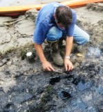
John Galbraith sampled oil-contaminated soils along the banks of the Mississippi River south of New Orleans in 2008. Photo by David C. Weindorf.
The research team was led by soil scientists David Weindorf from Louisiana State University, Cristine Morgan of Texas Agrilife Research, and John Galbraith from Virginia Tech. The method they investigated used visible near infrared light with diffuse reflectance spectroscopy, shining a light on a sample and reading the reflecting wavelengths. This allowed the researchers to rapidly evaluate soils for the presence and amount of oil contamination quickly while in the field, without sending a sample to a laboratory and waiting for test results. The technique was used to predict total petroleum hydrocarbons in a various soils in southern Louisiana.
Results from the study were reported in the July-August 2010 issue of the Journal of Environmental Quality, a publication of the American Society of Agronomy, the Crop Science Society of America, and the Soil Science Society of America. Funded by the Louisiana Applied Oil Spill Research Program, the research also was presented at Clean Gulf 2009 in New Orleans, and the 2009 Soil Science Society of America International Annual Meetings in Pittsburgh.
The study results demonstrated that the new method provided acceptable predictions of oil contamination compared to more traditional laboratory testing. The most successful method for scanning the materials was without additional drying and grinding, which released volatile hydrocarbons and caused inaccurate measurements. This indicates that on-site scanning of soils impacted by an oil spill provide superior results, since there is no loss of material through shipment or processing.
Somsubhra Chakraborty, LSU doctoral student and lead graduate student on the study, stated that “the present feasibility study indicated that successful combination of chemometry and spectrometry...looks really promising for developing a methodology to identify petroleum contaminated soils in the near future. The fact that this spectroscopic technology does not need prior sample preparation has made it particularly applicable.”
Research is ongoing at the Louisiana State University AgCenter to investigate the use of this method for mapping hydrocarbon contaminant plumes and evaluate the unique light signatures of different hydrocarbon compounds (tar, crude oil, diesel, and motor oil).
Other research is evaluating predictive models that would be used in conjunction with on-site analysis. Ultimately, this research may lead to the use of airborne or satellite platforms to provide a new means of assessing both known and unknown areas of oil spill contamination.