CUES Inc.
GPS Mapping Stick
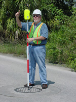
Used to precisely locate structures such as manholes, the Wireless GPS Mapping Stick from CUES collects sub-meter GPS coordinates and transmits them seamlessly into the Granite XP inspection software from a distance of up to 1,500 feet. Tracing the path of lines also can be recorded and updated into GIS maps to present detailed infrastructure layers, as well as linear references. The GPS data is associated to the specific asset identified in the field and then updated into GIS.